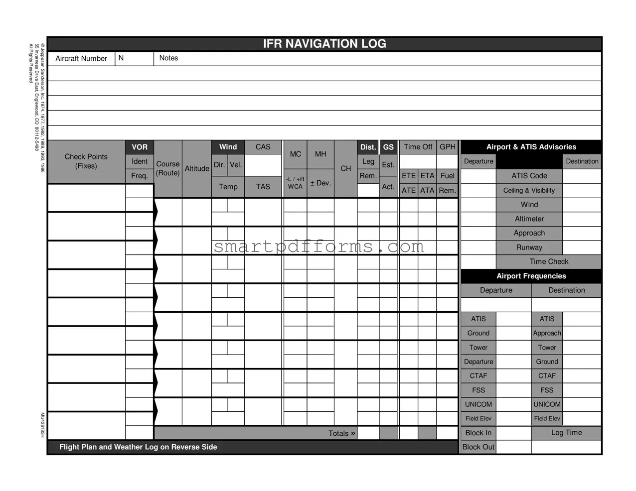
Blank Ifr Navigation Log PDF Template
Pilots navigating through the skies under Instrument Flight Rules (IFR) understand the importance of meticulous planning and precise information. The IFR Navigation Log form, a comprehensive tool created by Jeppesen Sanderson, Inc., serves as an essential component in this process. Originating from their headquarters at 55 Inverness Drive East, Englewood, CO, the form has seen several updates since its initial release in 1974, with revisions in years such as 1977, 1982, 1989, 1993, and 1996. It encompasses a wide array of data fields that pilots need to complete before and during their flight. This includes details about the aircraft, such as the number and notes, airport and ATIS advisories, checkpoints, course directions, estimated and actual times of arrival, fuel calculations, and wind adjustments. Furthermore, the form accommodates detailed weather logs, including ceiling, visibility, and precipitation, alongside forecasted and actual weather conditions. It also lays out the flight plan, specifying the type of flight, aircraft identification, departure points, routes, and destination details, among others. By systematically organizing this information, the IFR Navigation Log form ensures that pilots have a clear roadmap of their journey, aiding in navigation accuracy, safety, and regulatory compliance.
Preview - Ifr Navigation Log Form
AllRightsReserved |
55InvernessDriveEast, |
©JeppesenSanderson, |
|
|
|
|
|
IFR NAVIGATION LOG |
|
|
|
|
|
|||
Aircraft Number |
N |
Notes |
|
|
|
|
|
|
|
|
|
|
|
|||
|
|
|
|
|
|
|
|
|
|
|
|
|
|
|||
|
Englewood, CO |
Inc. 1974, 1977, |
|
|
|
|
|
|
|
|
|
|
|
|
|
|
|
1982, 1989,1993, |
|
VOR |
|
|
Wind |
CAS |
|
Dist. |
GS |
Time Off |
GPH |
Airport & ATIS Advisories |
|||
|
|
|
|
|
|
|
||||||||||
|
|
|
Check Points |
|
|
|
|
|
MC |
MH |
|
|
|
|
|
|
|
|
|
Ident |
|
|
|
|
|
Leg |
|
|
|
Departure |
|
Destination |
|
|
|
1996 |
(Fixes) |
Course |
|
Dir. Vel. |
|
|
Est. |
|
|
|
||||
|
|
|
Altitude |
|
|
CH |
|
|
|
|
|
|||||
|
|
|
Freq. |
(Route) |
|
|
|
|
ETE ETA |
Fuel |
|
ATIS Code |
||||
|
|
|
|
|
|
|
|
Rem. |
|
|
||||||
|
|
|
|
|
|
|
|
|
± Dev. |
|
|
|
|
|
|
|
|
|
|
|
|
|
|
Temp |
TAS |
WCA |
Act. |
|
|
|
|
|
|
|
|
|
|
|
|
|
|
ATE ATA Rem. |
|
Ceiling & Visibility |
||||||
|
|
|
|
|
|
|
|
|
|
|
|
|
||||
|
|
|
|
|
|
|
|
|
|
|
|
|
|
|
|
Wind |
|
|
|
|
|
|
|
|
|
|
|
|
|
|
|
|
Altimeter |
|
|
|
|
|
|
|
|
|
|
|
|
|
|
|
|
Approach |
|
|
|
|
|
|
|
|
|
|
|
|
|
|
|
|
Runway |
|
|
|
|
|
|
|
|
|
|
|
|
|
|
|
|
Time Check |
|
|
|
|
|
|
|
|
|
|
|
|
|
|
|
Airport Frequencies |
|
|
|
|
|
|
|
|
|
|
|
|
|
|
|
Departure |
Destination |
|
|
|
|
|
|
|
|
|
|
|
|
|
|
|
ATIS |
|
ATIS |
|
|
|
|
|
|
|
|
|
|
|
|
|
|
Ground |
|
Approach |
|
|
|
|
|
|
|
|
|
|
|
|
|
|
Tower |
|
Tower |
|
|
|
|
|
|
|
|
|
|
|
|
|
|
Departure |
|
Ground |
|
|
|
|
|
|
|
|
|
|
|
|
|
|
CTAF |
|
CTAF |
|
|
|
|
|
|
|
|
|
|
|
|
|
|
FSS |
|
FSS |
|
|
MU436183H |
|
|
|
|
|
|
|
|
|
|
|
UNICOM |
|
UNICOM |
|
|
|
|
|
|
|
|
|
Totals » |
|
|
|
Block In |
|
Log Time |
|
|
|
|
|
|
|
|
|
|
|
|
|
|
|
Field Elev |
|
Field Elev |
|
|
|
Flight Plan and Weather Log on Reverse Side |
|
|
|
|
|
|
Block Out |
|
|
||||

WEATHER LOG
Ceiling, Visibility and Precipitation
Reported |
Forecast |
|
|
Winds Aloft
Icing
and Freezing Level
Turbulence
and Cloud Tops
Position of Fronts,
Lows and Highs
Departure
Enroute
Destination
Alternate
FLIGHT PLAN
|
1. |
Type |
2. Aircraft |
3. Aircraft Type/ |
|
4. True |
5. Departure |
6. Departure Time |
7.Cruising |
|
|||
|
|
VFR |
Identification |
Special Equipment |
Airspeed |
Point |
|
Proposed (Z) |
Actual (Z) |
Altitude |
|
||
|
|
IFR |
|
|
|
|
|
|
|
|
|
|
|
|
|
DVFR |
|
|
|
|
Knots |
|
|
|
|
|
|
|
|
|
|
|
|
|
|
|
|
|
|
|
|
|
8. Route of Flight |
|
|
|
|
|
|
|
|
|
|
||
|
|
|
|
|
|
|
|
|
|
|
|
|
|
|
9. Destination (Name of airport and city) |
10. Est. Time Enroute |
11. Remarks |
|
|
|
|||||||
|
|
|
|
|
Hours |
|
Minutes |
|
|
|
|
|
|
|
|
|
|
|
|
|
|
|
|
|
|
|
|
|
|
12. Fuel on board |
13. Alternate Airport(s) |
|
14. Pilot's Name, Address, Tel # & Aircraft Home Base |
15. # Aboard |
|||||||
|
Hours |
Minutes |
|
|
|
|
|
|
|
|
|
|
|
|
|
|
|
|
|
|
|
|
|
|
|
|
|
|
16. Color of Aircraft |
|
|
17. Destination Contact / Telephone (Optional) |
|
|
|||||||
|
|
|
|
|
|
|
|
|
|
|
|
|
|
|
|
|
CLOSE VFR FLIGHT PLAN WITH _____________________ FSS ON ARRIVAL |
|
|||||||||
|
Special Equipment Suffix |
|
|
|
|
|
|
|
|||||
|
|
|
|
|
|
|
|
|
|
|
capability |
|
|
|
|
|
|||||||||||
|
|||||||||||||
|
Navigation Satellite System (GNSS) equipped |
||||||||||||
|
|
|
|
|
|
|
|
aircraft with ocianic, enrout, terminal, and GPS |
|||||
|
|
|
|
|
|
|
|
|
|
|
approach capability. |
|
|
|
|
|
|
|
|
|
|
|
|
|
|
|
|
Notes and NOTAMs
Position Report
Acft. |
Position |
Time |
Alt. |
IFR/ |
Est. |
Name |
|
Ident. |
VFR |
Next Fix |
Following Fix |
||||
|
|
|
|||||
|
|
|
|
|
|
|
Report Conditions Aloft - Cloud Tops, Bases, Layers, Visibility, Turbulence, Haze, Ice, Thunderstorms
Form Data
| Fact Name | Detail |
|---|---|
| Purpose | The IFR Navigation Log form is designed to help pilots plan and execute Instrument Flight Rules (IFR) flights efficiently by logging critical navigation and flight information. |
| Components | The form includes sections for recording data such as VOR wind, ground speed (GS), estimated and actual times enroute (ETE/ATE), fuel calculations, ATIS advisories, departure and destination airport frequencies, and weather logs. |
| Flight Plan Information | It also incorporates elements of the flight plan such as type of flight, aircraft and pilot information, route of flight, destination details, and special equipment codes to aid in flight tracking and safety. |
| Weather Log | Another critical component is the weather log for noting ceiling, visibility, winds aloft, icing conditions, turbulence, and the positions of weather fronts, which are essential for safe IFR flight. |
| Governing Laws | While the IFR Navigation Log form is primarily influenced by Federal Aviation Regulations (FARs) for its structure and requirements, specific state laws do not directly govern its use. However, pilots must comply with both federal and local regulations that impact flight planning and operations. |
Instructions on Utilizing Ifr Navigation Log
Filling out an IFR Navigation Log is a crucial step for pilots planning an instrument flight. This comprehensive form, while appearing daunting at first glance, is designed to ensure that all necessary information is accounted for before takeoff. From details about the aircraft and pilot to specifics about the intended route, weather conditions, and emergency plans, each section serves a critical role in flight safety and efficiency. Here's a straightforward guide on how to complete this form, broken down into manageable steps.
- Aircraft and Flight Information:
- Enter the aircraft number under the "Aircraft Number" section.
- Note any relevant information about the flight in the "Notes" section.
- Departure and Arrival Details:
- Fill out the airport name, ATIS code, and frequencies for both departure and destination airports.
- Specify the intended departure and destination times, including ETAs and ETEs.
- Route Information:
- Document your planned route, including all waypoints (fixes), VOR identifications, leg distances, and expected altitudes.
- Enter the true airspeed (TAS), wind direction and velocity, and calculate ground speed (GS) and wind correction angle (WCA).
- Weather Log:
- Under the "WEATHER LOG" section on the reverse side, record all necessary weather information including ceilings, visibility, winds aloft, and significant meteorological conditions from departure to destination.
- Flight Plan:
- Indicate the type of flight (IFR, VFR, DVFR) and any special equipment on board.
- Provide detailed information regarding your departure point, time, cruising altitude, route, destination, and estimated time enroute.
- Include remarks about the flight and specifics such as fuel onboard, alternate airports, pilot's contact information, passengers, aircraft color, and destination contact (if applicable).
- Final Review:
- Go through the entire form to ensure all information is accurate and nothing has been overlooked.
- Adjustments should be made for any inaccuracies or last-minute changes.
Completing the IFR Navigation Log meticulously is instrumental in planning a safe and efficient flight. It serves as a final checklist, enabling pilots to reassess their flight plan under the lens of current and forecasted conditions. By following these steps, pilots can mitigate risks and address any concerns well before taking to the skies.
Obtain Answers on Ifr Navigation Log
What is an IFR Navigation Log?
An IFR Navigation Log is a comprehensive document used by pilots performing instrument flight rules (IFR) flights. It assists in planning and executing the flight by tracking crucial details such as course headings, times, fuel consumption, weather conditions, and communication frequencies. The log ensures that all necessary information for the flight, from departure to arrival, is methodically organized and easily accessible.
Why is the IFR Navigation Log important?
The importance of the IFR Navigation Log lies in its function as a critical tool for ensuring flight safety and efficiency under IFR conditions. It provides a structured format for pilots to calculate and record navigation and fuel strategies, anticipate changes in weather, and communicate effectively with air traffic control (ATC). By meticulously filling out the log, pilots can significantly reduce the risks associated with instrument flight, such as disorientation or fuel miscalculation.
What information must be filled in an IFR Navigation Log?
- Aircraft number and type.
- Departure and destination airports, including frequencies and ATIS codes.
- Route of flight, including checkpoints and fixes, with magnetic courses and headings.
- Wind directions and velocities, ground speeds, estimated and actual times en route (ETE/ATE).
- Fuel usage rates and remaining amounts.
- Altitudes, including estimated and actual, and any deviation from planned altitudes.
- Weather conditions, including ceiling, visibility, winds aloft, icing, and turbulence information.
- Flight plan details, including aircraft identification, departure point and time, cruising altitude, and estimated time enroute.
How does the weather log section of the IFR Navigation Log help a pilot?
The weather log section is pivotal for a pilot's situational awareness, providing a snapshot of weather conditions over the course of the flight. It includes reported and forecasted conditions such as ceiling, visibility, winds aloft, precipitation, icing levels, turbulence, and the positions of fronts and pressure systems. This helps the pilot anticipate and prepare for potential weather challenges that might necessitate route adjustments or altitude changes, ensuring a safe and smooth flight.
Can the IFR Navigation Log be used for both VFR and IFR flights?
While primarily designed for IFR flights due to its detailed requirements for navigation and weather planning under instrument flight rules, the IFR Navigation Log can also serve as a valuable planning tool for visual flight rules (VFR) flights. It encourages thorough pre-flight planning and can enhance situational awareness by providing a structured way to log route, weather, and fuel considerations.
What are the special equipment suffix codes in the flight plan section?
Special equipment suffix codes are used in the flight plan to indicate the types of navigational and communication equipment on board the aircraft. These codes are critical for air traffic control to understand the capabilities of the aircraft, affecting clearances and routing. Examples include:
- /G for aircraft equipped with GPS or GNSS.
- /U for transponders with altitude encoding capability.
- /D for aircraft with DME, but no transponder.
- /A for aircraft equipped with DME and a transponder that includes altitude encoding capability.
How does a pilot determine wind correction angles (WCA) and true airspeed (TAS) using the IFR Navigation Log?
Pilots calculate wind correction angles and true airspeed based on wind data (direction and velocity) and their intended course and speed. The WCA ensures that despite crosswinds, the aircraft remains on the intended course. The TAS is adjusted based on altitude and temperature to ensure fuel and time calculations are accurate. These calculations are crucial for accurate navigation and fuel planning, particularly over long distances or in challenging weather conditions.
Is there a digital version of the IFR Navigation Log available?
Yes, digital versions of the IFR Navigation Log are available through various aviation software and mobile apps. These digital tools automate many of the calculations required for the log, reducing the potential for human error and saving time in flight preparation. They often include additional features such as real-time weather updates, GPS tracking, and direct submission of flight plans to ATC, further enhancing the utility and efficiency of flight planning.
Common mistakes
Filling out an IFR Navigation Log form is an essential process for pilots planning their flight paths under Instrument Flight Rules. However, errors can occur during this process, potentially affecting the safety and efficiency of the flight. Here are seven common mistakes:
- Incorrectly filling in the aircraft information: Pilots may mistakenly provide wrong details for the aircraft number or type. This information is critical for identifying the aircraft in flight plans and logs.
- Overlooking wind adjustments: Failing to accurately adjust for wind direction and velocity can lead to miscalculations in ground speed (GS), estimated time enroute (ETE), and fuel consumption, which are vital for successful navigation and safety.
- Errors in waypoint identification: Misidentifying checkpoints or VORs (VHF Omnidirectional Range) can lead to confusion and deviations from the intended flight path. Accurate identification ensures the aircraft remains on the correct course.
- Miscalculating fuel requirements: Incorrectly estimating fuel consumption (GPH) and not accounting for reserves can result in insufficient fuel for the journey, a critical error that can jeopardize flight safety.
- Not updating weather conditions: Weather plays a significant role in IFR navigation. Pilots must ensure they have the latest information on weather conditions, including ceiling, visibility, and winds aloft, to make informed decisions about flight paths and altitude adjustments.
- Skipping alternate airport planning: Neglecting to identify and plan for an alternate airport is a mistake that can lead to challenges if the destination airport becomes unavailable due to unforeseen circumstances.
- Incorrect entry of special equipment codes: Failing to accurately indicate the aircraft's special equipment, such as transponders or GPS, via the correct suffix code can affect air traffic control's ability to provide appropriate guidance and support.
Addressing these mistakes can improve the accuracy of the IFR Navigation Log, enhancing flight safety and efficiency. Pilots should double-check their work and stay updated on best practices for completing this crucial document.
Documents used along the form
Flight planning and execution involve a careful balance of skill, knowledge, and the right documentation. The IFR (Instrument Flight Rules) Navigation Log forms a critical component of this, but it's far from the only document pilots and flight teams rely on to ensure safe, efficient operations. Several other forms and documents are typically used alongside the IFR Navigation Log to complete this picture.
- Flight Plan Form: This is a document filed by a pilot or flight dispatcher with the local Civil Aviation Authority (e.g., the FAA in the United States) to notify them of the flight's details. It includes information such as the route, estimated times of departure and arrival, alternate airports, and pertinent details about the aircraft and crew.
- Weather Briefing: This includes a compilation of weather reports and forecasts, NOTAMs (Notices to Airmen), and any other relevant meteorological information for the flight. Pilots use this to plan routes, altitudes, and speeds that will ensure safety and efficiency.
- NOTAMs: Notices to Airmen are critical advisories that convey information essential to personnel involved in flight operations but not known far enough in advance to be publicized by other means.
- Weight and Balance Report: This document calculates the aircraft’s weight and center of gravity to ensure it is within acceptable limits for safe operation. It takes into account the weight of passengers, baggage, fuel, and any cargo.
- Aircraft Checklist: A comprehensive list covering pre-flight, in-flight, and post-flight checks. Pilots use this checklist to ensure every system and component in the aircraft is functioning correctly and is properly configured.
- Approach Plates: These are detailed charts used during the final approach phase of a flight, providing information on procedures and navigational aids for landing at specific airports.
- Aeronautical Charts: Maps designed for aviation use, displaying navigational information such as airspace boundaries, navigation aids, and topographical features that are important for flight planning and navigation.
- Pilot’s Operating Handbook (POH)/Airplane Flight Manual (AFM): A document specific to each aircraft that includes everything from operational data to emergency procedures. It’s the pilot’s go-to guide for safely operating the aircraft.
- Logbooks: Essential records for both the aircraft and the pilot, documenting flight time, maintenance, repairs, and inspections for the aircraft, as well as flight hours, training, and qualifications for the pilot.
Navigating the skies safely involves meticulous preparation and attention to detail, with the IFR Navigation Log playing a pivotal role among numerous other documents. By weaving together information from all these sources, pilots can ensure not only compliance with regulations but also the highest standards of flight safety and efficiency.
Similar forms
The VFR Flight Plan form is similar to the IFR Navigation Log as it collects essential information for flight planning but focuses on flights under Visual Flight Rules (VFR) conditions. Both forms request details like aircraft identification, departure and destination airports, estimated time enroute, and pilot information.
The Pilot's Weather Log shares similarities in that it gathers data on weather conditions, including ceiling, visibility, precipitation, and winds aloft. This information is critical for both IFR and VFR flight planning, and both documents emphasize the importance of thorough weather assessment.
Aircraft Performance Charts are akin to parts of the IFR Navigation Log concerning calculations for estimated time enroute (ETE), fuel consumption, and true airspeed (TAS). They both help pilots make crucial decisions based on the performance capabilities of their aircraft under specific conditions.
The Weight and Balance Calculation Sheets resemble the IFR Navigation Log since both necessitate accuracy in computations that affect flight safety and performance. While the IFR Navigation Log focuses on route planning, fuel, and time estimations, the weight and balance sheets ensure the aircraft is loaded within its allowable limits.
Flight Crew Briefing Forms are similar as they provide an organized way for flight crews to review vital information about the flight route, weather, and aircraft status. Both documents ensure that critical information is assessed and understood before departure.
The Airport Facility Directory (AFD), though more of a reference document, relates to parts of the IFR Navigation Log dealing with airport frequencies, field elevations, and approach procedures. Pilots use both to familiarize themselves with important details about their departure and destination airports.
NOTAM (Notices to Airmen) Briefings are relevant to the information found in the IFR Navigation Log's sections on notes and advisories. Both documents are crucial for conveying temporary but essential information affecting navigation and safety, such as construction, temporary airspace restrictions, or changes in airport service availability.
Dos and Don'ts
When completing the IFR Navigation Log, attention to detail and compliance with regulations ensure a safe and efficient flight plan. The following are suggestions on what you should and shouldn't do during this process:
- Do verify all the information you input, including aircraft number, departure and destination airports, estimated times, and fuel calculations. Accuracy in these details is crucial for flight safety.
- Do refer to the most current weather reports and NOTAMs (Notices to Airmen) before finalizing your log. Conditions can change, and your plan needs to reflect the latest data.
- Do ensure that all abbreviations and codes used, such as for special equipment or the aircraft type, are accurate and conform to the recognized standards. This helps in clear communication and compliance.
- Do include alternate airports in your flight plan, especially for IFR flights. This is not only a requirement under certain conditions but also a prudent safety measure.
- Don't forget to account for winds aloft in your navigation planning. Neglecting to adjust for wind speed and direction can lead to significant deviations from the intended path.
- Don't leave sections of the form blank unless they are truly not applicable. Incomplete forms can lead to misunderstandings or delays.
- Don't underestimate the importance of recording the departure and arrival times accurately. These timestamps are essential for tracking flight progress and ensuring adherence to the flight plan.
- Don't ignore the importance of double-checking frequencies for ATIS, tower, ground, CTAF, and FSS. Ensuring these are correct can significantly impact communication and compliance with air traffic control.
Compliance with these dos and don'ts can lead to not only a safer flight but also a smoother experience in navigating the complexities of IFR flight planning.
Misconceptions
There are several misconceptions regarding the IFR Navigation Log form that can mislead pilots and aviation enthusiasts alike. Here's a look at five common misunderstandings and the realities behind them.
It's only for commercial pilots: A common misconception is that the IFR Navigation Log form is strictly for use by commercial pilots. However, it is equally valuable for private pilots who are IFR rated. This document is essential for planning and executing IFR flights, ensuring that pilots have considered all aspects of navigation, including fuel requirements, weather, and airspace restrictions.
It's too complex for practical use: While the IFR Navigation Log form appears complex at first glance, it's designed to be comprehensive. It guides the pilot through every step of flight planning and execution, making it a vital tool for ensuring safety and compliance with regulations. With practice and proper instruction, its use becomes second nature.
It's optional for IFR flights: Another misconception is that the use of the IFR Navigation Log form is optional. In reality, while the FAA does not mandate a specific form, having a detailed navigation log for IFR flights is a crucial component of flight planning and is considered a best practice for ensuring a safe flight under instrument flight rules.
Technology has made it obsolete: With the advent of advanced avionics and GPS, some might think the IFR Navigation Log is unnecessary. However, understanding and manually planning a flight using the navigation log can provide invaluable insights into the flight's details. It also serves as a crucial backup in case of electronic failure.
It's only about plotting courses: The final misconception is that the IFR Navigation Log form is merely for plotting courses. In truth, it encompasses much more, including fuel calculation, weather logging, alternate airport planning, and noting air traffic control frequencies. It ensures a holistic approach to flight planning, emphasizing safety and regulatory compliance.
Understanding and accurately using the IFR Navigation Log is essential for pilots flying under instrument flight rules. It not only aids in compliance with aviation regulations but also significantly enhances safety and efficiency during flight.
Key takeaways
Filling out and understanding the IFR Navigation Log form is crucial for ensuring a safe and efficient flight plan under Instrument Flight Rules (IFR). Here are key takeaways to consider when dealing with the IFR Navigation Log.
- Accuracy is paramount. Each detail entered on the form, from aircraft number to destination airport and waypoints, needs to be accurate to ensure flight safety and regulatory compliance.
- Understanding weather information is critical. The Weather Log section provides space for noting ceiling, visibility, precipitation, winds aloft, icing, and turbulence, among other conditions. Interpreting this correctly influences route planning and safety precautions.
- The Flight Plan section captures essential details about the flight, including type, aircraft and pilot information, route, and alternate airports. This is key for both planning and in case of unforeseen changes.
- Navigation specifics such as True Course, Magnetic Course, Ground Speed, Estimated Time Enroute (ETE), and Fuel Consumption are vital for navigation and fuel planning. These figures must be calculated with precision.
- The form includes a section for NOTAMs (Notices to Airmen) and notes, which are essential for understanding temporary changes or conditions affecting the flight path that are not included in the standard briefing materials.
- Recording ATIS (Automatic Terminal Information Service) codes for both departure and destination airports, along with nearby frequencies for ATIS, Tower, Ground, and approach helps in maintaining awareness of the flight environment and ensures compliance with communication requirements.
- The Special Equipment Suffix section indicates the onboard navigation and communication equipment's capabilities. This informs air traffic control (ATC) about the aircraft's equipage, aiding in clearances and instructions.
Understanding and properly filling out the IFR Navigation Log is not just a matter of regulatory compliance; it is an integral part of flight planning that ensures safety, efficiency, and effectiveness in navigating under IFR conditions. Pilots should approach this task diligently, making use of all available resources and information to accurately complete each section.
Popular PDF Forms
Telemetry Rn - It aids in monitoring core measures and specific details related to cardiac health, surgeries, and potential risks like falls or infections.
Tenancy Agreement Meaning - Addresses every aspect of the tenancy relationship, from payments to property care, underpinned by the responsible authority of the National Landlords Association.